
In
|
One of the first things you should take a look at if you decide to come to Costa Rica is the geography of the region. Learn about the political divisions, the people and what you're going to find as you get around town.
|
|
General information on Costa Rica:
Official name: Republic of Costa Rica
Independence Date: September 15, 1821
Type of government: Democratic-Presidential
Population: 4 million
Territorial area: 52000 SqKm.
Official language: Spanish
Official religion: Roman Catholic
|
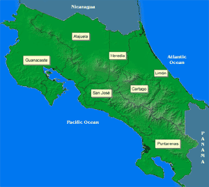
Click on the icons at any time to see bigger maps
|
Costa Rica is located in Central America, bordering on the southeast end with Panama and on the north with Nicaragua. It's a small country, roughly 52000 km2 in area. That's about the size of Biskmarck, South Dakota, or a bit smaller than the state of West Virginia. To give you a better idea, you can cross Pacific to Atlantic in about 7 or 8 hours by car.
The territory was formed by interaction between tectonic plates, and as the plates pushed against each other the country rose from the ocean. This type of formation has given Costa Rica, over millions of years, an irregular topography formed by long mountain and volcanic chains. The interaction between tectonic plates also makes Costa Rica prone to abundant seismic and volcanic activity.
One thing you'll probably notice when you get to Costa Rica is the abundance of mountain chains, formed by millions of years of plate subduction. These mountain chains form valleys, in which population tends to concentrate and cities form. San Jose and the Greater Metropolitan Area is located in the central valley. Many of the mountain chains also contain active volcanoes, which are a popular tourist attraction.
Political Division
Costa Rica is divided into 7 provinces, which are San José, Heredia, Alajuela, Cartago, Limón, Guanacaste and Puntarenas. Each province is then divided into cantones, which are political areas under the jurisdiction of a local municipality. Each cantón is then divided into a certain number of districts, depending on social, geographical and economic considerations.
The people


Population is completely balanced between sexes, with only very minor (7% at the most) differences in the different age groups; in those cases women outnumber men at the higher age groups (25 and over) and men outnumber women at lower groups (24 and under). Costa Rica has a very young population, with the most predominant age group being 10 to 14 years of age, followed by 5 to 9 and then 15 to 19. Population decreases from there on and reaches a minimum at the 70 to 74 year age group. Interestingly enough, 75 and over has a higher proportion than 70 to 74, possibly due to retiree inmigration or biological reasons.
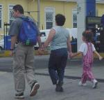
Culturally, you'll find a bit of everything. Central Valley population has a very strong north american orientation, but still conserves most of the local customs and culture in its social interaction. Limón has a profound caribbean influence, while pacific coast provinces such as Guanacaste and Puntarenas reflect more of the original culture of Costa Rica, but influenced in many parts by the presence of tourism centers.
Getting around town
Think finding addresses where you live is confusing? That's what you think. Outside the central areas, no organized street pattern exists, so you'll find addresses are given relative to known waypoints. These waypoints can be anything, from huge buildings and industries to statues and landmarks of historical value (I've seen a streetlamp used as a waypoint for example). That means you'll normally get your addresses as "go south 100 meters, west 200 meters, then south at the yellow house".
A map is something which can really help you out as you're learning to get around the country. Loads of maps exist in bookstores all over the country, from 1:500000 scale school maps to 1:5000 scale survey maps. Jiménez & Tanzi is a local print shop which publishes tourist and general orientation maps of the country. If you want more detail, official maps of the entire country are available from the National Geographical Institute, a subdivision of the Ministry of Transportation. The NGI has 1:50000 scale maps of the entire country, and 1:10000 scale maps of the larger metropolitan areas. There's also several intermediate scale maps for specific regions and aerial photographs of the entire country along differing timelines in different scales. Call 223-9384 ext 2619 or ext 2618 for more information, or write to igncr@mopt.go.cr.
Out
|
Now that you've got more or less an idea of how the country is distributed and what you're going to find as you explore, find out how our transportation system works, or what people do for a living, or take a look at my photo albums for an idea of what urban life is like down here. Or go back to the map for more interesting waypoints.
|